Weather Alert in Indiana
Flood Warning issued March 3 at 10:47PM EST until March 11 at 8:36AM EDT by NWS Indianapolis IN
AREAS AFFECTED: Daviess, IN; Greene, IN; Knox, IN
DESCRIPTION: ...The Flood Warning continues for the following rivers in Indiana... Haw Creek near Clifford. White River at Elliston. Youngs Creek at Amity. White River at Newberry. ...The Flood Warning is extended for the following rivers in Indiana... East Fork White River at Seymour. .Multiple rounds of rainfall over central Indiana over the next several days are expected to bring at least minor flooding on area rivers and streams. Flooding is expected to develop along portions of the East Fork White and lower White basins over the next 48 hours. Forecast crests issued today include rainfall amounts of 3 to 4 inches over large portions of the East Fork White and lower White basins from this morning through Friday morning, but additional rainfall expected from Friday onward will likely increase crests and lengthen the amount of time in flood. * WHAT...Minor flooding is forecast. * WHERE...White River at Elliston. * WHEN...From Wednesday evening to Wednesday, March 11. * IMPACTS...At 24.0 feet, State Road 157 between Worthington and Bloomfield begins to flood. County Road 175 south of Bloomfield floods. County Road 100 W between CR 110 N and SR 67 (Jefferson Twp), CR 850 N between SR 48 and SR 157 (Jefferson Twp), CR 250 W between SR 54 and CR 250 N (Fairplay Twp), CR 200 W between CR 157 S and CR 260 S (Washington Twp), CR 100 W between CR 100 S and CR 260 S (Washington Twp), and CR 100 W between CR 250 W and the White River affected by high water. * ADDITIONAL DETAILS... - At 8:00 AM EST Tuesday the stage was 8.8 feet. - Forecast...The river is expected to rise above flood stage tomorrow evening to a crest of 24.0 feet Saturday morning. It will then fall below flood stage Tuesday, March 10. - Flood stage is 18.0 feet. - http://www.weather.gov/safety/flood
INSTRUCTION: Stay tuned to further developments by listening to your local radio, television, or NOAA Weather Radio for further information. Be especially cautious at night when it is harder to recognize the dangers of flooding. Additional information is available at www.weather.gov/ind. The next statement should be issued Wednesday afternoon by around 100 PM EST.
Want more detail? Get the Complete 7 Day and Night Detailed Forecast!
Current U.S. National Radar--Current
The Current National Weather Radar is shown below with a UTC Time (subtract 5 hours from UTC to get Eastern Time).

National Weather Forecast--Current
The Current National Weather Forecast and National Weather Map are shown below.

National Weather Forecast for Tomorrow
Tomorrow National Weather Forecast and Tomorrow National Weather Map are show below.

North America Water Vapor (Moisture)
This map shows recent moisture content over North America. Bright and colored areas show high moisture (ie, clouds); brown indicates very little moisture present; black indicates no moisture.

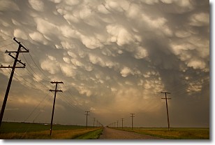
Weather Topic: What are Mammatus Clouds?
Home - Education - Cloud Types - Mammatus Clouds
 Next Topic: Nimbostratus Clouds
A mammatus cloud is a cloud with a unique feature which resembles
a web of pouches hanging along the base of the cloud.
In the United States, mammatus clouds tend to form in the warmer months, commonly
in the Midwest and eastern regions.
While they usually form at the bottom of a cumulonimbis cloud, they can also form
under altostratus, altocumulus, stratocumulus, and cirrus clouds. Mammatus clouds
warn that severe weather is close.
Next Topic: Nimbostratus Clouds
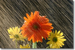
Weather Topic: What is Precipitation?
Home - Education - Precipitation - Precipitation
 Next Topic: Rain
Precipitation can refer to many different forms of water that
may fall from clouds. Precipitation occurs after a cloud has become saturated to
the point where its water particles are more dense than the air below the cloud.
In most cases, precipitation will reach the ground, but it is not uncommon for
precipitation to evaporate before it reaches the earth's surface.
When precipitation evaporates before it contacts the ground it is called Virga.
Graupel, hail, sleet, rain, drizzle, and snow are forms of precipitation, but fog
and mist are not considered precipitation because the water vapor which
constitutes them isn't dense enough to fall to the ground.
Next Topic: Rain
Current conditions powered by WeatherAPI.com


