Weather Alert in Minnesota
Flood Warning issued August 22 at 9:51AM CDT by NWS Twin Cities/Chanhassen MN
AREAS AFFECTED: Le Sueur, MN; Scott, MN; Sibley, MN
DESCRIPTION: ...The National Weather Service in the Twin Cities has issued a Flood Warning for the following rivers in Minnesota... Minnesota River at Henderson MN19 affecting Sibley, Le Sueur and Scott Counties. Minnesota River near Jordan affecting Sibley, Scott and Carver Counties. ...Forecast flooding changed from Minor to Moderate severity for the following rivers in Minnesota... Minnesota River at Montevideo affecting Chippewa, Yellow Medicine and Lac qui Parle Counties. .As water from storms over the past few weeks continue to move through the Minnesota River more points will rise above flood stage. Based on current forecasts additional warnings downriver are not anticipated. * WHAT...Minor flooding is forecast. * WHERE...Minnesota River at Henderson MN19. * WHEN...From Saturday afternoon until further notice. * IMPACTS...At 732.5 feet, Water begins encroaching on highway 19 east of Henderson. * ADDITIONAL DETAILS... - At 930 AM CDT Friday, the stage was 731.3 feet. - Forecast...The river is expected to rise above flood stage early tomorrow afternoon and continue rising to a crest of 732.5 feet early Monday morning. - Flood stage is 732.0 feet. - Flood History...This crest compares to a previous crest of 732.6 feet on 09/27/2018.
INSTRUCTION: Turn around, don't drown when encountering flooded roads. Most flood deaths occur in vehicles. Please report observed flooding to local emergency services or law enforcement and request they pass this information to the National Weather Service when you can do so safely.
Want more detail? Get the Complete 7 Day and Night Detailed Forecast!
Current U.S. National Radar--Current
The Current National Weather Radar is shown below with a UTC Time (subtract 5 hours from UTC to get Eastern Time).

National Weather Forecast--Current
The Current National Weather Forecast and National Weather Map are shown below.

National Weather Forecast for Tomorrow
Tomorrow National Weather Forecast and Tomorrow National Weather Map are show below.

North America Water Vapor (Moisture)
This map shows recent moisture content over North America. Bright and colored areas show high moisture (ie, clouds); brown indicates very little moisture present; black indicates no moisture.

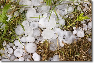
Weather Topic: What is Hail?
Home - Education - Precipitation - Hail
 Next Topic: Hole Punch Clouds
Hail is a form of precipitation which is recognized by large solid balls or
clumps of ice. Hail is created by thunderstorm clouds with strong updrafts of wind.
As the hailstones remain in the updraft, ice is deposited onto them until their
weight becomes heavy enough for them to fall to the earth's surface.
Hail storms can cause significant damage to crops, aircrafts, and man-made structures,
despite the fact that the duration is usually less than ten minutes.
Next Topic: Hole Punch Clouds
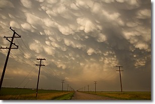
Weather Topic: What are Mammatus Clouds?
Home - Education - Cloud Types - Mammatus Clouds
 Next Topic: Nimbostratus Clouds
A mammatus cloud is a cloud with a unique feature which resembles
a web of pouches hanging along the base of the cloud.
In the United States, mammatus clouds tend to form in the warmer months, commonly
in the Midwest and eastern regions.
While they usually form at the bottom of a cumulonimbis cloud, they can also form
under altostratus, altocumulus, stratocumulus, and cirrus clouds. Mammatus clouds
warn that severe weather is close.
Next Topic: Nimbostratus Clouds
Current conditions powered by WeatherAPI.com


