Weather Alert in North Carolina
Extreme Heat Warning issued June 24 at 2:03AM EDT until June 25 at 8:00PM EDT by NWS Newport/Morehead City NC
AREAS AFFECTED: Martin; Pitt; Washington; Tyrrell; Mainland Dare; Greene; Beaufort; Mainland Hyde; Duplin; Lenoir; Jones; Pamlico; Northern Craven; Southern Craven; West Carteret; East Carteret; Inland Onslow; Coastal Onslow; Northern Outer Banks; Ocracoke Island; Hatteras Island
DESCRIPTION: * WHAT...For the Heat Advisory, heat index values of 105 to 110 expected. For the Extreme Heat Warning, dangerously hot conditions with heat index values of 110 to 115 expected. * WHERE...Portions of eastern North Carolina. * WHEN...For the Heat Advisory, until 10 AM EDT this morning. For the Extreme Heat Warning, from 10 AM this morning to 8 PM EDT Wednesday. * IMPACTS...Heat related illnesses increase significantly during extreme heat and high humidity events. Hot temperatures and high humidity may cause heat illnesses. * ADDITIONAL DETAILS...A dangerous, and longer-lasting, heatwave will continue to impact all of ENC through the middle of this week. The cumulative impact of the heat, along with little relief at night, will magnify the level of impact.
INSTRUCTION: Do not leave young children and pets in unattended vehicles. Car interiors will reach lethal temperatures in a matter of minutes. To reduce risk during outdoor work, the Occupational Safety and Health Administration recommends scheduling frequent rest breaks in shaded or air conditioned environments. Anyone overcome by heat should be moved to a cool and shaded location. Heat stroke is an emergency! Call 9 1 1.
Want more detail? Get the Complete 7 Day and Night Detailed Forecast!
Current U.S. National Radar--Current
The Current National Weather Radar is shown below with a UTC Time (subtract 5 hours from UTC to get Eastern Time).

National Weather Forecast--Current
The Current National Weather Forecast and National Weather Map are shown below.

National Weather Forecast for Tomorrow
Tomorrow National Weather Forecast and Tomorrow National Weather Map are show below.

North America Water Vapor (Moisture)
This map shows recent moisture content over North America. Bright and colored areas show high moisture (ie, clouds); brown indicates very little moisture present; black indicates no moisture.

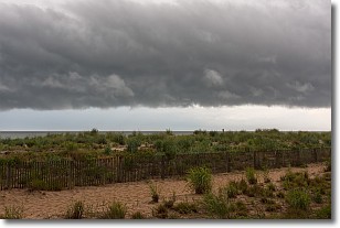
Weather Topic: What are Shelf Clouds?
Home - Education - Cloud Types - Shelf Clouds
 Next Topic: Sleet
A shelf cloud is similar to a wall cloud, but forms at the front
of a storm cloud, instead of at the rear, where wall clouds form.
A shelf cloud is caused by a series of events set into motion by the advancing
storm; first, cool air settles along the ground where precipitation has just fallen.
As the cool air is brought in, the warmer air is displaced, and rises above it,
because it is less dense. When the warmer air reaches the bottom of the storm cloud,
it begins to cool again, and the resulting condensation is a visible shelf cloud.
Next Topic: Sleet
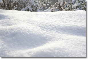
Weather Topic: What is Snow?
Home - Education - Precipitation - Snow
 Next Topic: Stratocumulus Clouds
Snow is precipitation taking the form of ice crystals. Each ice crystal, or snowflake,
has unique characteristics, but all of them grow in a hexagonal structure.
Snowfall can last for sustained periods of time and result in significant buildup
of snow on the ground.
On the earth's surface, snow starts out light and powdery, but as it begins to melt
it tends to become more granular, producing small bits of ice which have the consistency of
sand. After several cycles of melting and freezing, snow can become very dense
and ice-like, commonly known as snow pack.
Next Topic: Stratocumulus Clouds
Current conditions powered by WeatherAPI.com


