Weather Alert in Alaska
Hydrologic Outlook issued August 26 at 1:47PM AKDT by NWS Anchorage AK
AREAS AFFECTED: Anchorage; Anchorage Hillside / Eagle River; East Turnagain Arm; Portage; Lower Matanuska Valley; Hatcher Pass; Sutton / Upper Matanuska Valley; Eureka / Tahneta Pass; Southern Kachemak Bay; SW Kenai Peninsula; NW Kenai Peninsula; Skilak Lake; Southern Kenai Mtns; Interior Kenai Peninsula; Turnagain Pass; West Prince William Sound & Whittier; Tyonek; Valdez; Thompson Pass; Cordova; Western Susitna Valley; Southern Susitna Valley; Central Susitna Valley; Northern Susitna Valley
DESCRIPTION: ESFAFC Rainfall: * Eastern Kenai Peninsula and Prince William Sound: 2 to 4 inches with locally higher amounts in higher terrain. * Mat-Su Valley: 1 to 3 inches with locally higher amounts. The highest rainfall totals are likely to be across the northern Susitna Valley. * Western Kenai Peninsula and Anchorage: 1 to 2 inches of rainfall with the heaviest rainfall occuring adjacent to Cook Inlet. Downsloping at times may result in localized lower amounts immediately west of the mountains. Hydrologic Concerns * Expect sharp rises on many small streams and rivers. Many smaller streams will crest Thursday night into Friday while larger rivers or downstream points may crest Friday and Saturday. Higher than normal water levels may continue through Labor Day Weekend into next week. * Many lower locations along rivers such as gravel bars and other spots popular for camping and recreating are likely to become inundated with water. * Heavy rain may result in localized ponding in low-lying areas and locations with poor drainage. Confidence and Next Steps * Confidence is high that a multi-day heavy rainfall event will occur across Southcentral Alaska, with the northern Susitna Valley and Prince William Sound receiving the heaviest rainfall. Confidence is medium regarding rainfall totals and placement of heaviest rainfall. If forecast rainfall totals hold or increase, flood watches may be needed for portions of the Kenai Peninsula, Mat-Su Valley, or elsewhere. * Residents along area streams as well as river users and recreationists should anticipate higher than normal water levels and are advised to monitor weather and river forecasts. * Reports on river conditions may be sent to the river forecast center by calling 1-800-847-1739.
INSTRUCTION: N/A
Want more detail? Get the Complete 7 Day and Night Detailed Forecast!
Current U.S. National Radar--Current
The Current National Weather Radar is shown below with a UTC Time (subtract 5 hours from UTC to get Eastern Time).

National Weather Forecast--Current
The Current National Weather Forecast and National Weather Map are shown below.

National Weather Forecast for Tomorrow
Tomorrow National Weather Forecast and Tomorrow National Weather Map are show below.

North America Water Vapor (Moisture)
This map shows recent moisture content over North America. Bright and colored areas show high moisture (ie, clouds); brown indicates very little moisture present; black indicates no moisture.

Weather Topic: What is Hail?
Home - Education - Precipitation - Hail
 Next Topic: Hole Punch Clouds
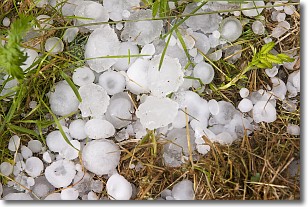
Hail is a form of precipitation which is recognized by large solid balls or
clumps of ice. Hail is created by thunderstorm clouds with strong updrafts of wind.
As the hailstones remain in the updraft, ice is deposited onto them until their
weight becomes heavy enough for them to fall to the earth's surface.
Hail storms can cause significant damage to crops, aircrafts, and man-made structures,
despite the fact that the duration is usually less than ten minutes.
Next Topic: Hole Punch Clouds
Weather Topic: What are Mammatus Clouds?
Home - Education - Cloud Types - Mammatus Clouds
 Next Topic: Nimbostratus Clouds
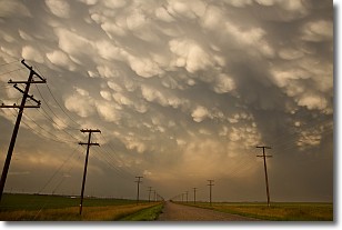
A mammatus cloud is a cloud with a unique feature which resembles
a web of pouches hanging along the base of the cloud.
In the United States, mammatus clouds tend to form in the warmer months, commonly
in the Midwest and eastern regions.
While they usually form at the bottom of a cumulonimbis cloud, they can also form
under altostratus, altocumulus, stratocumulus, and cirrus clouds. Mammatus clouds
warn that severe weather is close.
Next Topic: Nimbostratus Clouds
Current conditions powered by WeatherAPI.com


