Weather Alert in Montana
Special Weather Statement issued August 30 at 5:07AM MDT by NWS Great Falls MT
AREAS AFFECTED: Northern High Plains; Eastern Glacier, Western Toole, and Central Pondera; Eastern Toole and Liberty; Southern High Plains; Eastern Pondera and Eastern Teton; Cascade County below 5000ft; Gates of the Mountains
DESCRIPTION: Patchy dense fog has developed this morning for areas east of the Rockies, out to about the I-15 corridor from Craig to Sweet Grass. The dense fog is reducing visibility below a quarter of mile at times. The dense fog will like dissipate in most areas between 9 and 10 AM. Those who have travel plans this morning over the western half of North Central MT should be prepared for quickly changing visibility conditions and are reminded to slow down in areas of poor visibility.
INSTRUCTION: N/A
Want more detail? Get the Complete 7 Day and Night Detailed Forecast!
Current U.S. National Radar--Current
The Current National Weather Radar is shown below with a UTC Time (subtract 5 hours from UTC to get Eastern Time).

National Weather Forecast--Current
The Current National Weather Forecast and National Weather Map are shown below.

National Weather Forecast for Tomorrow
Tomorrow National Weather Forecast and Tomorrow National Weather Map are show below.

North America Water Vapor (Moisture)
This map shows recent moisture content over North America. Bright and colored areas show high moisture (ie, clouds); brown indicates very little moisture present; black indicates no moisture.

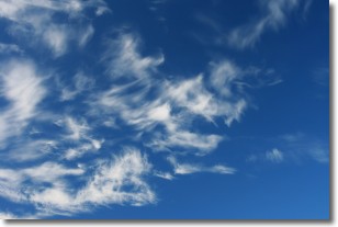
Weather Topic: What are Cirrostratus Clouds?
Home - Education - Cloud Types - Cirrostratus Clouds
 Next Topic: Cirrus Clouds
Cirrostratus clouds are high, thin clouds that form above
20,000 feet and are made mostly of ice crystals. They sometimes look like giant
feathers, horse tails, or curls of hair in the sky.
These clouds are pushed by the jet stream and can move at high speeds reaching
100 mph.
What do they indicate?
They indicate that a precipitation is likely within 24 hours.
Next Topic: Cirrus Clouds
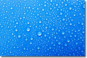
Weather Topic: What is Condensation?
Home - Education - Precipitation - Condensation
 Next Topic: Contrails
Condensation is the process which creates clouds, and therefore
it is a crucial process in the water cycle.
Condensation is the change of matter from a state of gas into a state of liquid,
and it happens because water molecules release heat into the atmosphere and
become organized into a more closely packed structure, what we might see as
water droplets.
Water is always present in the air around us as a vapor, but it's too small for
us to see. When water undergoes the process of condensation it becomes organized
into visible water droplets. You've probably seen condensation happen before on the
surface of a cold drink!
Next Topic: Contrails
Current conditions powered by WeatherAPI.com


