Weather Alert in Minnesota
Winter Storm Warning issued April 3 at 2:55PM CDT until April 4 at 10:00PM CDT by NWS Twin Cities/Chanhassen MN
AREAS AFFECTED: Douglas; Todd; Morrison
DESCRIPTION: ...MIXED WINTER EVENT WITH SNOW, SLEET, AND ICE ACCUMULATION THROUGH SATURDAY... .A mixed precipitation event will persist across Minnesota into Wisconsin through Saturday. Across parts of central Minnesota, this will mainly fall as snow with up to 7 inches possible. Farther south, a band of freezing rain and sleet from southwest Minnesota to northwest Wisconsin will see ice accumulations up to two tenths of an inch. There will be a sharp cutoff in these ice accumulations, as this will be very sensitive to where the freezing line sets up. * WHAT...Heavy mixed precipitation expected. Total snow accumulations between 4 and 7 inches and ice accumulations around one tenth of an inch. * WHERE...Morrison, Todd, and Douglas Counties. * WHEN...Until 10 PM CDT Saturday. * IMPACTS...Travel could be very difficult. The hazardous conditions will impact the Friday evening commute.
INSTRUCTION: If you must travel, keep an extra flashlight, food, and water in your vehicle in case of an emergency. Call 5 1 1 or visit 511mn.org for road conditions.
Want more detail? Get the Complete 7 Day and Night Detailed Forecast!
Current U.S. National Radar--Current
The Current National Weather Radar is shown below with a UTC Time (subtract 5 hours from UTC to get Eastern Time).

National Weather Forecast--Current
The Current National Weather Forecast and National Weather Map are shown below.

National Weather Forecast for Tomorrow
Tomorrow National Weather Forecast and Tomorrow National Weather Map are show below.

North America Water Vapor (Moisture)
This map shows recent moisture content over North America. Bright and colored areas show high moisture (ie, clouds); brown indicates very little moisture present; black indicates no moisture.

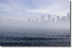
Weather Topic: What is Fog?
Home - Education - Cloud Types - Fog
 Next Topic: Fractus Clouds
Fog is technically a type of stratus cloud, which lies along the
ground and obscures visibility.
It is usually created when humidity in the air condenses into tiny water droplets.
Because of this, some places are more prone to foggy weather, such as regions
close to a body of water.
Fog is similar to mist; both are the appearance of water droplets suspended in
the air, but fog is the term applied to the condition when visibility is less than 1 km.
Next Topic: Fractus Clouds
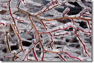
Weather Topic: What is Freezing Rain?
Home - Education - Precipitation - Freezing Rain
 Next Topic: Graupel
Freezing rain is a condition where precipitation which has fallen in the form of
water droplets reaches temperatures which are below freezing and freezes upon
coming into contact
with surface objects. The result of this precipitation is a glaze of ice which
can be damaging to plants and man-made structures. A severe onset of freezing
rain which results in a very thick glaze of ice is known as an ice storm.
Next Topic: Graupel
Current conditions powered by WeatherAPI.com


