Weather Alert in Iowa
Severe Thunderstorm Watch issued August 15 at 2:16PM CDT until August 15 at 7:00PM CDT by NWS Quad Cities IA IL
AREAS AFFECTED: Benton, IA; Buchanan, IA; Cedar, IA; Clinton, IA; Delaware, IA; Dubuque, IA; Iowa, IA; Jackson, IA; Johnson, IA; Jones, IA; Keokuk, IA; Linn, IA; Louisa, IA; Muscatine, IA; Scott, IA; Washington, IA; Carroll, IL; Henry, IL; Jo Daviess, IL; Mercer, IL; Rock Island, IL; Whiteside, IL
DESCRIPTION: THE NATIONAL WEATHER SERVICE HAS ISSUED SEVERE THUNDERSTORM WATCH 590 IN EFFECT UNTIL 7 PM CDT THIS EVENING FOR THE FOLLOWING AREAS IN ILLINOIS THIS WATCH INCLUDES 6 COUNTIES IN NORTHWEST ILLINOIS CARROLL HENRY IL JO DAVIESS MERCER ROCK ISLAND WHITESIDE IN IOWA THIS WATCH INCLUDES 16 COUNTIES IN EAST CENTRAL IOWA BENTON CEDAR CLINTON IOWA JACKSON JOHNSON JONES LINN MUSCATINE SCOTT IN NORTHEAST IOWA BUCHANAN DELAWARE DUBUQUE IN SOUTHEAST IOWA KEOKUK LOUISA WASHINGTON THIS INCLUDES THE CITIES OF ALEDO, ANAMOSA, BETTENDORF, CEDAR RAPIDS, CLINTON, CREDIT ISLAND, DAVENPORT, DUBUQUE, GALENA, GENESEO, INDEPENDENCE, IOWA CITY, MANCHESTER, MAQUOKETA, MARENGO, MOLINE, MOUNT CARROLL, MUSCATINE, ROCK ISLAND, SIGOURNEY, STERLING, TIPTON, VINTON, WAPELLO, AND WASHINGTON. * PRIMARY THREATS INCLUDE... SCATTERED DAMAGING WIND GUSTS TO 70 MPH POSSIBLE. ISOLATED LARGE HAIL EVENTS TO 1.5 INCHES IN DIAMETER POSSIBLE. PROBABILITY TABLE: PROB OF 2 OR MORE TORNADOES : 10% PROB OF 1 OR MORE STRONG /EF2-EF5/ TORNADOES : <02% PROB OF 10 OR MORE SEVERE WIND EVENTS : 40% PROB OF 1 OR MORE WIND EVENTS >= 75 MPH : 20% PROB OF 10 OR MORE SEVERE HAIL EVENTS : 20% PROB OF 1 OR MORE HAIL EVENTS >= 2 INCHES : 10% PROB OF 6 OR MORE COMBINED SEVERE HAIL/WIND EVENTS : 60% MEAN STORM MOTION /MPH/ : E 40
INSTRUCTION: N/A
Want more detail? Get the Complete 7 Day and Night Detailed Forecast!
Current U.S. National Radar--Current
The Current National Weather Radar is shown below with a UTC Time (subtract 5 hours from UTC to get Eastern Time).

National Weather Forecast--Current
The Current National Weather Forecast and National Weather Map are shown below.

National Weather Forecast for Tomorrow
Tomorrow National Weather Forecast and Tomorrow National Weather Map are show below.

North America Water Vapor (Moisture)
This map shows recent moisture content over North America. Bright and colored areas show high moisture (ie, clouds); brown indicates very little moisture present; black indicates no moisture.

Weather Topic: What is Snow?
Home - Education - Precipitation - Snow
 Next Topic: Stratocumulus Clouds
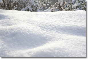
Snow is precipitation taking the form of ice crystals. Each ice crystal, or snowflake,
has unique characteristics, but all of them grow in a hexagonal structure.
Snowfall can last for sustained periods of time and result in significant buildup
of snow on the ground.
On the earth's surface, snow starts out light and powdery, but as it begins to melt
it tends to become more granular, producing small bits of ice which have the consistency of
sand. After several cycles of melting and freezing, snow can become very dense
and ice-like, commonly known as snow pack.
Next Topic: Stratocumulus Clouds
Weather Topic: What are Stratus Clouds?
Home - Education - Cloud Types - Stratus Clouds
 Next Topic: Wall Clouds
Stratus clouds are similar to altostratus clouds, but form at a
lower altitude and are identified by their fog-like appearance, lacking the
distinguishing features of most clouds.
Stratus clouds are wider than most clouds, and their base has a smooth, uniform
look which is lighter in color than a nimbostratus cloud.
The presence of a stratus cloud indicates the possibility of minor precipitation,
such as drizzle, but heavier precipitation does not typically arrive in the form
of a stratus cloud.
Next Topic: Wall Clouds
Current conditions powered by WeatherAPI.com


