Weather Alert in Michigan
Flood Watch issued April 2 at 12:50PM EDT until April 6 at 2:00PM EDT by NWS Grand Rapids MI
AREAS AFFECTED: Newaygo
DESCRIPTION: ...The National Weather Service in Grand Rapids MI has issued a Flood Watch for the following rivers in Michigan... Muskegon River at Newaygo affecting Newaygo County. Muskegon River at Bridgeton affecting Newaygo County. .1 To 2 inches of rain has fallen in recent days, with an additional 1 to 2 inches expected over the next few days. The Muskegon River has begun to rise, and flooding may develop by this weekend. * WHAT...Flooding is possible. * WHERE...Muskegon River at Bridgeton. * WHEN...From late Saturday night to early Monday afternoon. * IMPACTS...At 13.0 feet, Water overflows the banks into wooded areas. * ADDITIONAL DETAILS... - At 10:00 AM EDT Thursday the stage was 9.8 feet. - Forecast...Flood stage may be reached early Sunday morning. - Flood stage is 13.0 feet. - http://www.weather.gov/safety/flood
INSTRUCTION: Residents and those with interests near the river should monitor rising water levels and be prepared for possible flood warnings. Stay tuned to further developments by listening to your local radio, television, or NOAA Weather Radio for further information. Additional information is available at www.weather.gov/grr.
Want more detail? Get the Complete 7 Day and Night Detailed Forecast!
Current U.S. National Radar--Current
The Current National Weather Radar is shown below with a UTC Time (subtract 5 hours from UTC to get Eastern Time).

National Weather Forecast--Current
The Current National Weather Forecast and National Weather Map are shown below.

National Weather Forecast for Tomorrow
Tomorrow National Weather Forecast and Tomorrow National Weather Map are show below.

North America Water Vapor (Moisture)
This map shows recent moisture content over North America. Bright and colored areas show high moisture (ie, clouds); brown indicates very little moisture present; black indicates no moisture.

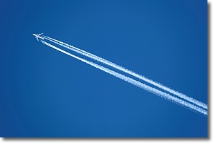
Weather Topic: What are Contrails?
Home - Education - Cloud Types - Contrails
 Next Topic: Cumulonimbus Clouds
A contrail is an artificial cloud, created by the passing of an
aircraft.
Contrails form because water vapor in the exhaust of aircraft engines is suspended
in the air under certain temperatures and humidity conditions. These contrails
are called exhaust contrails.
Another type of contrail can form due to a temporary reduction in air pressure
moving over the plane's surface, causing condensation.
These are called aerodynamic contrails.
When you can see your breath on a cold day, it is also because of condensation.
The reason contrails last longer than the condensation from your breath is
because the water in contrails freezes into ice particles.
Next Topic: Cumulonimbus Clouds
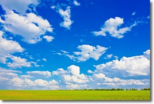
Weather Topic: What are Cumulus Clouds?
Home - Education - Cloud Types - Cumulus Clouds
 Next Topic: Drizzle
Cumulus clouds are fluffy and textured with rounded tops, and
may have flat bottoms. The border of a cumulus cloud
is clearly defined, and can have the appearance of cotton or cauliflower.
Cumulus clouds form at low altitudes (rarely above 2 km) but can grow very tall,
becoming cumulus congestus and possibly the even taller cumulonimbus clouds.
When cumulus clouds become taller, they have a greater chance of producing precipitation.
Next Topic: Drizzle
Current conditions powered by WeatherAPI.com


