Weather Alert in Alaska
Flood Advisory issued September 10 at 4:06PM AKDT until September 13 at 10:00AM AKDT by NWS Anchorage AK
AREAS AFFECTED: Western Susitna Valley; Southern Susitna Valley; Central Susitna Valley
DESCRIPTION: * WHAT...Flooding caused by excessive rainfall is expected. * WHERE...the Yentna River near Lake Creek. * WHEN...Until 1000 AM AKDT Saturday. * IMPACTS...At 20.5 feet, water begins to inundate several low-lying cabins. * ADDITIONAL DETAILS... - At 252 PM AKDT, the YLKA2 river gauge indicated rises in water levels from heavy rain across the advisory area. Water levels at the Yentna River near Lake Creek are near bankfull. Minor flooding in low lying areas is expected to begin late Thursday evening. - At 1:00 PM AKDT, Between 0.5 and 1 inch of rain have fallen. Additional rainfall amounts of 1 to 2 inches are possible. The river level is at Action Stage and is expected to reach Minor Flood stage at 10 PM AKDT Thursday. Forecast: A crest around 20.8 feet is expected late Friday morning with an estimated crest time at 10 AM AKDT Friday. The river will then begin to fall and is expected to go below flood stage by Saturday morning. - Http://www.weather.gov/safety/flood
INSTRUCTION: Stay tuned to further developments by listening to your local radio, television, or NOAA Weather Radio for further information.
Want more detail? Get the Complete 7 Day and Night Detailed Forecast!
Current U.S. National Radar--Current
The Current National Weather Radar is shown below with a UTC Time (subtract 5 hours from UTC to get Eastern Time).

National Weather Forecast--Current
The Current National Weather Forecast and National Weather Map are shown below.

National Weather Forecast for Tomorrow
Tomorrow National Weather Forecast and Tomorrow National Weather Map are show below.

North America Water Vapor (Moisture)
This map shows recent moisture content over North America. Bright and colored areas show high moisture (ie, clouds); brown indicates very little moisture present; black indicates no moisture.

Weather Topic: What are Fractus Clouds?
Home - Education - Cloud Types - Fractus Clouds
 Next Topic: Freezing Rain
A fractus cloud (scud) is a fragmented, tattered cloud which has
likely been sheared off of another cloud. They are accessory clouds, meaning they
develop from parent clouds, and are named in a way which describes the original
cloud which contained them.
Fractus clouds which have originated from cumulus clouds are referred to as
cumulus fractus, while fractus clouds which have originated from stratus clouds
are referred to as stratus fractus. Under certain conditions a fractus cloud might
merge with another cloud, or develop into a cumulus cloud, but usually a
fractus cloud seen by itself will dissipate rapidly.
They are often observed on the leading and trailing edges of storm clouds,
and are a display of wind activity.
Next Topic: Freezing Rain
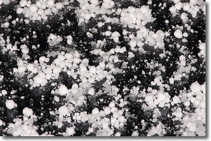
Weather Topic: What is Graupel?
Home - Education - Precipitation - Graupel
 Next Topic: Hail
Graupel is a form of precipitation that is created by atmospheric conditions
which cause supercooled water droplets to contact snow crystals and freeze to
their surface.
Sometimes known as soft hail or snow pellets, graupel is delicate and easily
destroyed by touch. Whereas hail usually falls during severe weather, graupel
doesn't require such conditions to form, and can form in mild precipitation
similar to situations which produce snowfall.
Next Topic: Hail
Current conditions powered by WeatherAPI.com


