Weather Alert in Indiana
Flood Warning issued March 7 at 12:56PM EST until March 8 at 1:00AM EST by NWS Indianapolis IN
AREAS AFFECTED: Bartholomew, IN
DESCRIPTION: ...The Flood Warning continues for the following rivers in Indiana... East Fork White River near Bedford, Rivervale, Williams, and Shoals. Driftwood River near Edinburgh. ...The Flood Warning is extended for the following rivers in Indiana... East Fork White River at Columbus and Seymour. .Total rainfall amounts of 3 to over 5 inches of rain across much of central and southern Indiana is bringing widespread moderate flooding across the East Fork White basin and their tributaries. Additional rainfall earlier today, and next week could lengthen the amount of time area rivers remain in flood or bring additional rises next week. * WHAT...Minor flooding is occurring and minor flooding is forecast. * WHERE...Flatrock River near Columbus. * WHEN...Until just after midnight tonight. * IMPACTS...At 12.0 feet, On April 6, 2011 after reaching 13 feet... Noblitt Park...CR 400N and Owens Bend Park remained flooded. * ADDITIONAL DETAILS... - At 12:30 PM EST Saturday the stage was 11.3 feet. - Recent Activity...The maximum river stage in the 24 hours ending at 12:30 PM EST Saturday was 14.6 feet. - Forecast...The river is expected to rise to a crest of 11.4 feet this afternoon. It will then fall below flood stage this evening. - Flood stage is 11.0 feet. - http://www.weather.gov/safety/flood
INSTRUCTION: Flooding is occurring or is imminent. Most flood related deaths occur in automobiles. Do not attempt to cross water covered bridges, dips, or low water crossings. Never try to cross a flowing stream, even a small one, on foot. To escape rising water find another route over higher ground. Caution is urged when walking near riverbanks. Additional information is available at www.weather.gov/ind. The next statement should be issued this evening by around 800 PM EST.
Want more detail? Get the Complete 7 Day and Night Detailed Forecast!
Current U.S. National Radar--Current
The Current National Weather Radar is shown below with a UTC Time (subtract 5 hours from UTC to get Eastern Time).

National Weather Forecast--Current
The Current National Weather Forecast and National Weather Map are shown below.

National Weather Forecast for Tomorrow
Tomorrow National Weather Forecast and Tomorrow National Weather Map are show below.

North America Water Vapor (Moisture)
This map shows recent moisture content over North America. Bright and colored areas show high moisture (ie, clouds); brown indicates very little moisture present; black indicates no moisture.

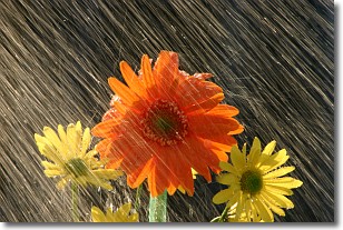
Weather Topic: What is Precipitation?
Home - Education - Precipitation - Precipitation
 Next Topic: Rain
Precipitation can refer to many different forms of water that
may fall from clouds. Precipitation occurs after a cloud has become saturated to
the point where its water particles are more dense than the air below the cloud.
In most cases, precipitation will reach the ground, but it is not uncommon for
precipitation to evaporate before it reaches the earth's surface.
When precipitation evaporates before it contacts the ground it is called Virga.
Graupel, hail, sleet, rain, drizzle, and snow are forms of precipitation, but fog
and mist are not considered precipitation because the water vapor which
constitutes them isn't dense enough to fall to the ground.
Next Topic: Rain
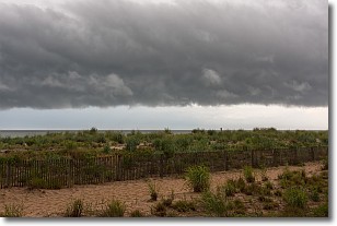
Weather Topic: What are Shelf Clouds?
Home - Education - Cloud Types - Shelf Clouds
 Next Topic: Sleet
A shelf cloud is similar to a wall cloud, but forms at the front
of a storm cloud, instead of at the rear, where wall clouds form.
A shelf cloud is caused by a series of events set into motion by the advancing
storm; first, cool air settles along the ground where precipitation has just fallen.
As the cool air is brought in, the warmer air is displaced, and rises above it,
because it is less dense. When the warmer air reaches the bottom of the storm cloud,
it begins to cool again, and the resulting condensation is a visible shelf cloud.
Next Topic: Sleet
Current conditions powered by WeatherAPI.com


