Weather Alert in Pennsylvania
Heat Advisory issued July 29 at 10:20PM EDT until July 30 at 8:00PM EDT by NWS State College PA
AREAS AFFECTED: Southern Centre; Blair; Huntingdon; Mifflin; Juniata; Bedford; Fulton; Franklin; Southern Clinton; Southern Lycoming; Union; Snyder; Montour; Northumberland; Columbia; Perry; Dauphin; Schuylkill; Lebanon; Cumberland; Adams; York; Lancaster
DESCRIPTION: * WHAT...Heat index values up to 104. * WHERE...A portion of central Pennsylvania. * WHEN...Until 8 PM EDT Wednesday. * IMPACTS...Hot temperatures and high humidity may cause heat illnesses.
INSTRUCTION: Young children and pets should never be left unattended in vehicles under any circumstances. This is especially true during hot weather when car interiors can reach lethal temperatures in a matter of minutes. LOOK BEFORE YOU LOCK. Know the signs and symptoms of heat exhaustion and heat stroke. Review heat safety and preparedness information at weather.gov/safety/heat. In addition to the daytime heat, overnight low temperatures will also be very warm and oppressively muggy.
Want more detail? Get the Complete 7 Day and Night Detailed Forecast!
Current U.S. National Radar--Current
The Current National Weather Radar is shown below with a UTC Time (subtract 5 hours from UTC to get Eastern Time).

National Weather Forecast--Current
The Current National Weather Forecast and National Weather Map are shown below.

National Weather Forecast for Tomorrow
Tomorrow National Weather Forecast and Tomorrow National Weather Map are show below.

North America Water Vapor (Moisture)
This map shows recent moisture content over North America. Bright and colored areas show high moisture (ie, clouds); brown indicates very little moisture present; black indicates no moisture.

Weather Topic: What are Contrails?
Home - Education - Cloud Types - Contrails
 Next Topic: Cumulonimbus Clouds
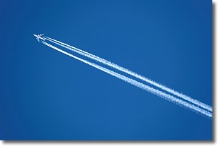
A contrail is an artificial cloud, created by the passing of an
aircraft.
Contrails form because water vapor in the exhaust of aircraft engines is suspended
in the air under certain temperatures and humidity conditions. These contrails
are called exhaust contrails.
Another type of contrail can form due to a temporary reduction in air pressure
moving over the plane's surface, causing condensation.
These are called aerodynamic contrails.
When you can see your breath on a cold day, it is also because of condensation.
The reason contrails last longer than the condensation from your breath is
because the water in contrails freezes into ice particles.
Next Topic: Cumulonimbus Clouds
Weather Topic: What are Cumulus Clouds?
Home - Education - Cloud Types - Cumulus Clouds
 Next Topic: Drizzle
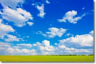
Cumulus clouds are fluffy and textured with rounded tops, and
may have flat bottoms. The border of a cumulus cloud
is clearly defined, and can have the appearance of cotton or cauliflower.
Cumulus clouds form at low altitudes (rarely above 2 km) but can grow very tall,
becoming cumulus congestus and possibly the even taller cumulonimbus clouds.
When cumulus clouds become taller, they have a greater chance of producing precipitation.
Next Topic: Drizzle
Current conditions powered by WeatherAPI.com


