Weather Alert in Oregon
Red Flag Warning issued August 21 at 1:17PM PDT until August 22 at 11:00PM PDT by NWS Pendleton OR
AREAS AFFECTED: Warm Springs Reservation
DESCRIPTION: ...LOCALLY BREEZY WITH LOW RELATIVE HUMIDITY FRIDAY... .As a heat wave moves over the region, a transitory period will allow for locally breezy conditions along the east slopes of the Oregon Cascades. The Warm Springs Reservation in particular, as well as southeastern Wasco and northeastern Jefferson Counties, are expected to see critical fire weather conditions during the day Friday as RHs drop well into the teens. The National Weather Service in Pendleton has issued a Red Flag Warning for wind and low relative humidity, which is in effect from 2 PM to 11 PM PDT Friday. The Fire Weather Watch is no longer in effect. * AFFECTED AREA...Fire Weather Zone 703 Warm Springs Reservation. * TIMING...From 2 PM to 11 PM PDT Friday. * WINDS...Northeast 10 to 15 mph with gusts up to 25 mph. * RELATIVE HUMIDITY...As low as 12 percent. * IMPACTS...Any fire that develops will catch and spread quickly. Outdoor burning is not recommended.
INSTRUCTION: A Red Flag Warning means that critical fire weather conditions are either occurring now, or will shortly. A combination of strong winds, low relative humidity, and warm temperatures can contribute to extreme fire behavior.
Want more detail? Get the Complete 7 Day and Night Detailed Forecast!
Current U.S. National Radar--Current
The Current National Weather Radar is shown below with a UTC Time (subtract 5 hours from UTC to get Eastern Time).

National Weather Forecast--Current
The Current National Weather Forecast and National Weather Map are shown below.

National Weather Forecast for Tomorrow
Tomorrow National Weather Forecast and Tomorrow National Weather Map are show below.

North America Water Vapor (Moisture)
This map shows recent moisture content over North America. Bright and colored areas show high moisture (ie, clouds); brown indicates very little moisture present; black indicates no moisture.

Weather Topic: What are Shelf Clouds?
Home - Education - Cloud Types - Shelf Clouds
 Next Topic: Sleet
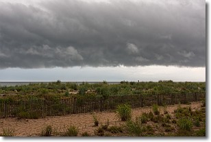
A shelf cloud is similar to a wall cloud, but forms at the front
of a storm cloud, instead of at the rear, where wall clouds form.
A shelf cloud is caused by a series of events set into motion by the advancing
storm; first, cool air settles along the ground where precipitation has just fallen.
As the cool air is brought in, the warmer air is displaced, and rises above it,
because it is less dense. When the warmer air reaches the bottom of the storm cloud,
it begins to cool again, and the resulting condensation is a visible shelf cloud.
Next Topic: Sleet
Weather Topic: What is Snow?
Home - Education - Precipitation - Snow
 Next Topic: Stratocumulus Clouds
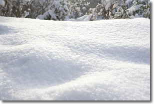
Snow is precipitation taking the form of ice crystals. Each ice crystal, or snowflake,
has unique characteristics, but all of them grow in a hexagonal structure.
Snowfall can last for sustained periods of time and result in significant buildup
of snow on the ground.
On the earth's surface, snow starts out light and powdery, but as it begins to melt
it tends to become more granular, producing small bits of ice which have the consistency of
sand. After several cycles of melting and freezing, snow can become very dense
and ice-like, commonly known as snow pack.
Next Topic: Stratocumulus Clouds
Current conditions powered by WeatherAPI.com


