Weather Alerts for California
1. Extreme Heat Warning for: Coalinga - Avenal; Fresno-Clovis; West Side Mountains South of 198; Buena Vista; Bakersfield; South End San Joaquin Valley; Fresno-Tulare Foothills; South End Sierra Foothills
2. Extreme Heat Warning for: Cuyama Valley; Santa Clarita Valley; Santa Lucia Mountains; Southern Salinas Valley; San Luis Obispo County Interior Valleys; San Luis Obispo County Mountains; Santa Ynez Valley; Santa Barbara County Interior Mountains; Western Santa Monica Mountains Recreational Area; Calabasas and Agoura Hills; Western San Fernando Valley; Eastern San Fernando Valley; Southeastern Ventura County Valleys; Santa Susana Mountains; Southern Ventura County Mountains; Northern Ventura County Mountains; Interstate 5 Corridor; Western San Gabriel Mountains and Highway 14 Corridor; Eastern San Gabriel Mountains; Western Antelope Valley Foothills; Eastern Antelope Valley Foothills; Antelope Valley; Los Angeles County San Gabriel Valley
3. Extreme Heat Warning for: Indian Wells Valley; Mojave Desert Slopes; Mojave Desert
4. Extreme Heat Warning for: Santa Ynez Mountains Western Range; Santa Ynez Mountains Eastern Range; Los Angeles County Inland Coast including Downtown Los Angeles; Eastern Santa Monica Mountains Recreational Area
5. Extreme Heat Warning for: West Side Mountains north of 198; Mariposa Madera Foothills
6. Extreme Heat Warning for: Western Siskiyou County; Central Siskiyou County
7. Heat Advisory for: Lake Casitas; Ojai Valley; Central Ventura County Valleys
8. Heat Advisory for: Lassen-Eastern Plumas-Eastern Sierra Counties
9. Heat Advisory for: Los Banos - Dos Palos; Merced - Madera - Mendota; Planada - Le Grand - Snelling
10. Heat Advisory for: West Side of Fresno and Kings Counties; Caruthers - San Joaquin - Selma; Buttonwillow - Lost Hills - I5; Delano-Wasco-Shafter; Hanford - Corcoran - Lemoore; Visalia - Porterville - Reedley; Southeast San Joaquin Valley; Kern River Valley
11. Red Flag Warning for: Western Klamath National Forest; Central Siskiyou County Including Shasta Valley; Siskiyou County from the Cascade Mountains East and South to Mt Shasta; Modoc County Except for the Surprise Valley; Siskiyou Mountains; Southern Oregon Cascades; Klamath Basin and the Fremont-Winema National Forest; South Central Oregon Desert including the BLM Land in Eastern Lake and Western Harney Counties
Want more detail? Get the Complete 7 Day and Night Detailed Forecast!
Current U.S. National Radar--Current
The Current National Weather Radar is shown below with a UTC Time (subtract 5 hours from UTC to get Eastern Time).

National Weather Forecast--Current
The Current National Weather Forecast and National Weather Map are shown below.

National Weather Forecast for Tomorrow
Tomorrow National Weather Forecast and Tomorrow National Weather Map are show below.

North America Water Vapor (Moisture)
This map shows recent moisture content over North America. Bright and colored areas show high moisture (ie, clouds); brown indicates very little moisture present; black indicates no moisture.

Weather Topic: What are Altostratus Clouds?
Home - Education - Cloud Types - Altostratus Clouds
 Next Topic: Cirrocumulus Clouds
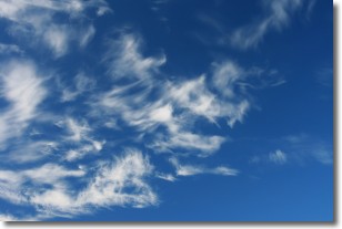
Altostratus clouds form at mid to high-level altitudes
(between 2 and 7 km) and are created by a warm, stable air mass which causes
water vapor
to condense as it rise through the atmosphere. Usually altostratus clouds are
featureless sheets characterized by a uniform color.
In some cases, wind punching through the cloud formation may give it a waved
appearance, called altostratus undulatus. Altostratus clouds
are commonly seen with other cloud formations accompanying them.
Next Topic: Cirrocumulus Clouds
Weather Topic: What are Cirrostratus Clouds?
Home - Education - Cloud Types - Cirrostratus Clouds
 Next Topic: Cirrus Clouds
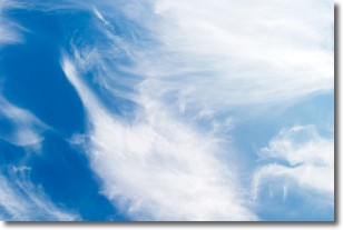
Cirrostratus clouds are high, thin clouds that form above
20,000 feet and are made mostly of ice crystals. They sometimes look like giant
feathers, horse tails, or curls of hair in the sky.
These clouds are pushed by the jet stream and can move at high speeds reaching
100 mph.
What do they indicate?
They indicate that a precipitation is likely within 24 hours.
Next Topic: Cirrus Clouds
Current conditions powered by WeatherAPI.com


