Weather Alerts for California
1. Air Quality Alert for: Imperial County Southwest; Imperial County West; Imperial Valley
2. High Wind Warning for: Death Valley National Park
3. Lake Wind Advisory for: Lassen-Eastern Plumas-Eastern Sierra Counties; Greater Lake Tahoe Area; Mono; Greater Lake Tahoe Area
4. Wind Advisory for: Apple and Lucerne Valleys; San Diego County Deserts
5. Wind Advisory for: Central Siskiyou County
6. Wind Advisory for: Eastern Sierra Slopes of Inyo County; White Mountains of Inyo County; Owens Valley South; Owens Valley North; Lincoln County
7. Wind Advisory for: Imperial County Southwest
8. Wind Advisory for: Indian Wells Valley; Mojave Desert
9. Wind Advisory for: Interstate 5 Corridor; Western San Gabriel Mountains and Highway 14 Corridor; Eastern San Gabriel Mountains; Western Antelope Valley Foothills; Eastern Antelope Valley Foothills; Antelope Valley
10. Wind Advisory for: Mojave Desert Slopes
11. Wind Advisory for: Riverside County Mountains; San Diego County Mountains
12. Wind Advisory for: San Bernardino County Mountains
13. Wind Advisory for: San Gorgonio Pass Near Banning
14. Winter Storm Warning for: Lassen Volcanic National Park; Sierra Nevada of Tehama-Butte-Plumas Counties Above 3000 ft; Sierra Nevada of Sierra-Nevada-Placer Counties Above 5000 ft Including Interstate 80; Sierra Nevada of El Dorado-Amador-Northern Alpine Counties Above 5000 ft Including Highway 50; Sierra Nevada of Calaveras-Tuolumne-Southern Alpine Counties Above 5000 ft
15. Winter Storm Warning for: Yosemite NP outside of the valley; Upper San Joaquin River; Kaiser to Rodgers Ridge; Kings Canyon NP; Sequoia NP
16. Winter Weather Advisory for: Greater Lake Tahoe Area; Greater Lake Tahoe Area
17. Winter Weather Advisory for: Mono
18. Winter Weather Advisory for: Northeastern Trinity
19. Winter Weather Advisory for: Western Siskiyou County; Central Siskiyou County; South Central Siskiyou County
Want more detail? Get the Complete 7 Day and Night Detailed Forecast!
Current U.S. National Radar--Current
The Current National Weather Radar is shown below with a UTC Time (subtract 5 hours from UTC to get Eastern Time).

National Weather Forecast--Current
The Current National Weather Forecast and National Weather Map are shown below.

National Weather Forecast for Tomorrow
Tomorrow National Weather Forecast and Tomorrow National Weather Map are show below.

North America Water Vapor (Moisture)
This map shows recent moisture content over North America. Bright and colored areas show high moisture (ie, clouds); brown indicates very little moisture present; black indicates no moisture.

Weather Topic: What is Condensation?
Home - Education - Precipitation - Condensation
 Next Topic: Contrails
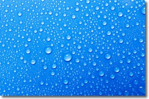
Condensation is the process which creates clouds, and therefore
it is a crucial process in the water cycle.
Condensation is the change of matter from a state of gas into a state of liquid,
and it happens because water molecules release heat into the atmosphere and
become organized into a more closely packed structure, what we might see as
water droplets.
Water is always present in the air around us as a vapor, but it's too small for
us to see. When water undergoes the process of condensation it becomes organized
into visible water droplets. You've probably seen condensation happen before on the
surface of a cold drink!
Next Topic: Contrails
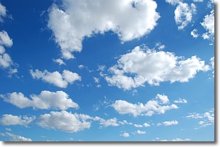
Weather Topic: What are Cumulonimbus Clouds?
Home - Education - Cloud Types - Cumulonimbus Clouds
 Next Topic: Cumulus Clouds
The final form taken by a growing cumulus cloud is the
cumulonimbus cloud, which is very tall and dense.
The tower of a cumulonimbus cloud can soar 23 km into the atmosphere, although
most commonly they stop growing at an altitude of 6 km.
Even small cumulonimbus clouds appear very large in comparison to other cloud types.
They can signal the approach of stormy weather, such as thunderstorms or blizzards.
Next Topic: Cumulus Clouds
Current conditions powered by WeatherAPI.com


